Golspie High School
Geography Department
Physical Environments
In this unit pupils will gain a deeper knowledge and understanding of the natural processes and interactions at work within a selection of landscapes in Scotland and the UK. These are glaciated landscapes and coastlines. Pupils will investigate how various features are formed, how the land is used in each area as well as any conflicts that may occur. Pupils will also study atmosphere and the impact it has on the world. As well as Biosphere where pupils will look as soils, how they are formed, how we use them and how we manage them.

Biosphere
What you need to know:
- Soil profiles (Podzol, Brown Forest Soil and Tundra Gley Soil)
- The differences between the soils
- Soil Forming Factors
BIOSPHERE GLOSSARY:
Brown Forest Soils – another name for brown earth soil
Parent Material – the rocks from which a soil has weathered.
Soil Biota – Living organisms within the soil
The three soil types that you need to know about are podzols, tundra gley soils and brown earth soils. For each you need to know how they were formed, their properties and what there profiles look like.
Firstly you need to know what factors influence soils formation.
1. Parent material – significant in the early development of soil and its mineral content. Parent material influences – rate of weathering (softer rock will weather more quickly), chemical composition soils from granite are more acidic than soils from chalk are more alkaline), soil colour (soils from iron bedrock are generally red in colour) and soil texture (is important as the courser it is the more permeable it will be e.g. soil from sandstone is coarse therefore water can permeate through it easily whereas soils from clay parent material are not well aerated and are prone to waterlogging).
2. Biotic factors – Vegetation and organisms all interact and produce organic material and humus that can be found in soil. It can affect the pH of the soil aswell as mixing of the soil.
3. Climate – Changes in temperature will affect the rate of soil formation particularly organic decomposition e.g. colder temperatures slow down the rate of decomposition. Also, the amount of precipitation will affect the soil as leaching may occur which will remove soluble minerals and humus)
4. Relief – Will affect the drainage and depth of the soil.
5. Time – Soils take a long time to develop fully. When they are young they take on a lot of properties from the parent material. This is true for the soils in Scotland are relatively young only forming after the last ice age.
6. Human Activity – e.g. the application of fertilisers etc. will affect the chemical composition and alter the soil characteristics
______________________________________________________________________________
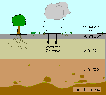
SOIL HORIZONS and PROFILES
___________________________________________________________________________
PODZOLS
*Podzols are found in areas of Northern coniferous forest or Taiga areas of Europe.
* Climate – long cool or cold winters with short mild to warm summers where precipitation is greater than evaporation.
* Natural vegetation – Coniferous trees. Ground litter is pines and needles that creates an acidic humus called mor.
*Type of Soil – Heavy with aluminium and Iron. It has clearly defined horizons. The upper A horizon has an ash grey colour due to leaching. The B Horizon is red/dark brown in colour due to the deposits of iron, clay mud and humus. In the B Horizon an iron-pan layer can form if iron accumulates over a long period of time. This Iron pan can impede drainage. The C Horizon is weathered parent material normally consisting of fluvioglacial sand or till.
* Processes – The climate plays a major part, there is a lack temperature meaning decomposition is slow and there is a lack of biota to mix and fertilise the soil. Heavy precipitation causes leaching of the soil (downward movement of minerals and humus). There is a formation of an Iron pan which restricts root action and causes waterlogging, especially in spring after the snow has melted.
* Human Factor – Due to climate there is a short growing season. It main use is commercial coniferous forest.
__________________________________________________________________________________
BROWN EARTH SOIL
*Location – Temperate Deciduous Forest, found in central Europe, Russia and North America
* Relief – Gently rolling land which allows free draining
*Climate – Less extreme condition than that of Podzols. Warmer conditions, lower precipitation, allowing more rapid decomposition.
*Natural vegetation – deciduous woodland, with beech and ash trees. Leaf litter is plentiful and thick. Humus is less acidic and called mull.
* Type of Soil – Horizons less distinctive due to greater mixing. A milder less acidic, slightly more alkaline soil. The A horizon well aerated due to earthworm and insect activity and has a loamy texture and is dark brown in colour. The B horizon is less distinct and is lighter in colour, as the humus is less abundant. The C Horizon is derived from parent material such as limestone and schist. Tree roots can penetrate as far down as the C horizon.
* Processes – Climate has less of an influence, not as much leaching takes place. Iron pan can still develop if leaching does take place.
* Human Factor – Due to greater amount of biota activity it is more fertile than a podzol soil therefore is good for agriculture, Due to this there a=is a greater population found in areas of Brown Earth soil. The land is also suitable for housing, industry and leisure.
___________________________________________________________________________________
GLEY SOILS
* Location – Found in areas with Permafrost (tundra) or areas with very poor drainage (Dartmoor)
* Relief – Flat areas with poor drainage
* Climate – Cold and wet (important factor is that there is little warmth in the soil.
* Natural Vegetation – vegetation growth is limited due to the cold climate and waterlogging. What vegetation there is are mosses and lichens.
* Type of soil – Leaching and lack of soil movement means that it is a strong zonal soil.
* Processes – There is very little or no oxygen found in the soil and is very waterlogged. The lack of oxygen causes anaerobic conditions. Leaf litter is slow in being broken down due to waterlogging. The A horizon is dark greyish brown in colour a nd the B horizon is blue/greyish in colour. The B Horizon is greyish in colour due to the leaching of the iron compounds in the soil. The C horizon consists of impermeable clay parent material.
*Human Factor – Limited use. Can be drained, ploughed and chemicals applied so low-value crops can be grown. Also used to keep sheep.
I can not find a decent profile for a gley soil so you will have to look at the textbook for that.
Examples of questions are:-
“Select a soil profile you have studied and with the aid of an annotated sketch, explain how the major soil forming factors have contributed to its formation”
“For profiles A and B, describe and then identify each soil type, giving your reasons


Atmosphere
WHAT YOU NEED TO KNOW:-
– Latitude and Energy Balance
– Global Variations in Received Solar Energy
– Variations in Global Temperature
– Patters of Ocean Currents
– Patterns of Surface Winds/Circulation Cells
– Climate of a Particular Place in West Africa
– Rainfall Variation/distribution in West Africa (ICTZ)
ATMOSPHERE GLOSSARY
Circulation Cell – A part of the atmosphere within which air circulates vertically e.g. Hadley, Ferrel and Polar cells
Energy Budget/Balance – Relate to the balance between solar and terrestrial radiation
Isohyet – A line on the map which joins places of equal rainfall
Joule – A unit of energy
Received Solar Energy – The solar radiation which passes through the atmosphere to reach the earth’s surface
Terrestrial Radiation – The long-wave heat energy which escapes from the earth’s surface
For more info on the atmosphere check out the BBC website.
Lithosphere
You need to know the following:-
– Mass Movement (rockfall/scree formation and landslip/slumping)
– Erosional Processes
– Glaciated Uplands – formation of physical features (Erosion, deposition and fluvio-glacial deposition) and O.S map work
– Coasts – Erosion (wave-cut notch/platforms, cave, blowhole, arch, stack, stump, cove,headland and bay) and deposition (beach, spit, bar/lagoon and tombolo
Hydrosphere
What you need to Know
– Analysis of River Flow Data
HYDROSPHERE GLOSSARY
Basin Lag – The time it takes for precipitation to make its way into the main river by run-off, tributary flow and throughflow of soil and ground water
Discharge – The volume of water in a river the passes in a given time – usually measured in cubic meters per second (cumecs)
Helicoidal Flow – The corcksrew flow or the river as it moves downstream
Inputs – Water which enters the drainage basin
Outputs – the water that leaves the drainage basin by transpiration, evaporation and rivers
Riffles – Shallow areas of the river bed
Storage – Water that is held in the basin
Transfers – The sideways movement water through the basin
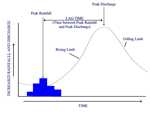
HYDROGRAPHS
Depending on the amount and pattern of precipitation will depend on how a river behaves. The characteristics of the drainage basin will also play apart in thedischarge of a river. Variables that will affect surface run-off and affect the shape of a storm hydrograph are :-
*Vegetation – little or none will result in rapid run-off whereas dense vegetation such as forests will result in slow run-off.
* Rock Type – Impermeable (granite) or permeable (chalk)
*Slope – steep or flat
* Ground Cover – Urban will have a rapid run-off and farmland will have a slow run-off
* Depth of Water Table – Close to the surface will have a faster run-off than if the water table was deep underground
* Precipitation – Heavy and intensive will produce more run-off than low or gentle
* Temperature – High temperatures will result in high evaporation causing slow run-off and low temps will result in lower evaporation causing higher amounts of run-off.
A river discharge is measured as part of river basin management in this country it is normally carried out by the Scottish Environmental Protection Agency, at river gauging stations. Discharge data is used along with precipitation data to construct short-period HYDROGRAPHS.
From analysing a hydrograph you can determine a rivers peak discharge and how this relates to peak rainfall,as well as lag time (the gap between maximum rainfall and the river reaching its maximum level). You can also tell the speed at which the water level in the river declines after its peak flow (Recessional or Falling limb). You can also tell what the river base flow is (normal level) and the period of time which the run-off or discharge is measured and recorded.
When analysing a Hydrograph, mention the following:-
1. River discharge does not increase immediately since only a small mount rain falls directly into a river.
2. Overland flow/surface run-off.
3. Throughflow will supplement the surface run-off
4. Rising limb shows overland flow and falling limb will indicate that there is still water in the system from throughflow, surface water and water in streams.
5. Mention lay time and discharge.
6. Rivers with a short lag time and high discharge are more likely to flood.
Checkout the BBC Bitesize webpage for good info on hydrographs
An exam style question would be ” Describe and account for the changes in discharge levels of the river shown in the hydrograph below” or “Describe the relationship between rainfall and discharge” you may also be asked to compare to different graphs or explain the differences between an urban graph and a rural graph.